Atlas of Guatemala
The introductions of the country, dependency and region entries are in the native languages and in English. The other introductions are in English.
| | |
This file has annotations. Move the mouse pointer over the image to see them. |
Guatemala
|

|
|
|
| Guatemala |
|
|
| Español | Guatemala - República de Guatemala
La República de Guatemala, del náhuatl: Coactimaltlan: "Territorio muy arbolado", o "País de muchos bosques" , es un país de la América Central, el más septentrional del istmo. Limita al norte y occidente con México, al nororiente con Belice y el Mar Caribe, al sur con el Océano Pacífico y al suroriente con Honduras y El Salvador. Su geografía física es gran parte montañosa. Posee suaves playas en su litoral del Pacífico y planicies bajas al norte del país. Es atravesado en su parte central por la Sierra Madre del Sur. |
| English | Guatemala - Republic of Guatemala
The Republic of Guatemala is a country in Central America, in the south part of North America, bordering ► Mexico to the northwest, the Pacific Ocean to the southwest, ► Belize and the Caribbean Sea to the northeast, and ► Honduras and ► El Salvador to the southeast. |
|
|
| Short name | Guatemala |
| Official name | Republic of Guatemala |
| Status | Independent country since 1821 |
| Location | Central America |
| Capital | Ciudad de Guatemala (Guatemala City) |
| Population | 12,800,000 inhabitants |
| Area | 108,890 km² |
| Major languages | Spanish (official), Mayan languages |
| Major religions | Roman Catholicism, Protestantism |
| More information | Guatemala, Geography of Guatemala, History of Guatemala and Politics of Guatemala |
| More images | Guatemala - Guatemala (Category). |
|
General maps
 | Mapa de Guatemala
Blank SVG map of Guatemala for geolocation |
 | Mapa de Guatemala
Map of Guatemala |
Departamento de
Department of Alta Verapaz
Departamento de Baja Verapaz
Department of Baja Verapaz
Departamento de Chimaltenango
Department of Chimaltenango
Departamento de Chiquimula
Department of Chiquimula
Departamento de El Petén
Department of El Petén
Departamento de El Progreso
Department of El Progreso
Departamento de El Quiché
Department of El Quiché
Departamento de Escuintla
Department of Escuintla
Departamento de Guatemala
Department of Guatemala
Departamento de Huehuetenago
Department of Huehuetenago
Departamento de Izabal
Department of Izabal
Departamento de Jalapa
Department of Jalapa
Departamento de Jutiapa
Department of Jutiapa
Departamento de Quetzaltenango
Department of Quetzaltenango
Departamento de Retalhuleu
Department of Retalhuleu
Departamento de Sacatepéquez
Department of Sacatepéquez
Departamento de San Marcos
Department of San Marcos
Departamento de Santa Rosa
Department of Santa Rosa
Departamento de Sololá
Department of Sololá
Departamento de Suchitepequez
Department of Suchitepequez
Departamento de Totonicapán
Department of Totonicapán
Departamento de Zacapa
Department of Zacapa
History maps
This section holds a short summary of the history of the area of present-day Guatemala, illustrated with maps, including historical maps of former countries and empires that included present-day Guatemala.
 | La cultura maya comparada con los estados contemporanos
Maya civilization compared with present states |
 | Las lenguas Maya
Maya languages |
Old maps
This section holds copies of original general maps older than 70 years of this entry.
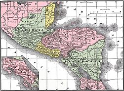 | América central en 1892
Central America in 1892 |
Linguistic maps
 | Languages of Guatemala |
Notes and references


